Green Creek
Map
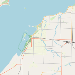
Leaflet | <a href="https://www.openstreetmap.org/copyright">© OpenStreetMap contributors</a>
Item
| Property | Value |
|---|---|
| id | 2038760 |
| downstream_mainstem_id | https://geoconnex.us/ref/mainstems/2038323 |
| encompassing_mainstem_basins | ['https://geoconnex.us/ref/mainstems/2038323'] |
| featuretype | ['https://www.opengis.net/def/schema/hy_features/hyf/HY_FlowPath', 'https://www.opengis.net/def/schema/hy_features/hyf/HY_WaterBody'] |
| fid | 6662 |
| head_2020huc12 | 040601020501 |
| head_nhdpv1_comid | 12129498 |
| head_nhdpv2_comid | https://geoconnex.us/nhdplusv2/comid/12129498 |
| head_nhdpv2huc12 | https://geoconnex.us/nhdplusv2/huc12/040601020501 |
| head_rf1id | 10921 |
| lengthkm | 15.9 |
| name_at_outlet | Green Creek |
| name_at_outlet_gnis_id | 627290 |
| new_mainstemid | |
| outlet_2020huc12 | 040601020501 |
| outlet_drainagearea_sqkm | 81.8 |
| outlet_nhdpv1_comid | 12130696 |
| outlet_nhdpv2_comid | https://geoconnex.us/nhdplusv2/comid/12130696 |
| outlet_nhdpv2huc12 | https://geoconnex.us/nhdplusv2/huc12/040601020501 |
| outlet_rf1id | 10921 |
| superseded | False |
| uri | https://geoconnex.us/ref/mainstems/2038760 |